Dec 1: Day Without Art

Each time I put together a December-time project, I run up against and am reawakened to the Day Without Art. Established in 1989 by Visual Aids as a “mourning and action in response to the AIDS crisis” to honor the accomplishments and reflect on the voices and visions lost to that disease. My intention to push out art on this day is really the only reason I am repeatedly made aware of the reason behind this season(day). I rely on the notion that how we come to a point of reflection is far less important than the fact that we indeed reach it, and give it space.
In this era where, with advanced treatment regimes, HIV has become a “manageable chronic condition,” it’s quite easy to forget the waves of deaths that were occurring unabated at the dawn of the ’80s, first due to the very mystery of the disease, then because of the denial and denigration of the victims on the part of the U.S governmental health establishment. It took time, and relentless pressure, aided by the disease’s escape from a ghetto of otherness into broader culture that finally bent resources toward addressing that plight.
Since then a different plague came and went, with more futures lost. And today in the U.S., we have a man-made affliction that is expanding on a foundation of silenced voices.
The road toward a remedy is no different whether the plague is biological or cultural in its nature. It starts with simply taking a moment to recognize and reflect on what’s been lost.
Dec 2: Greg Slick
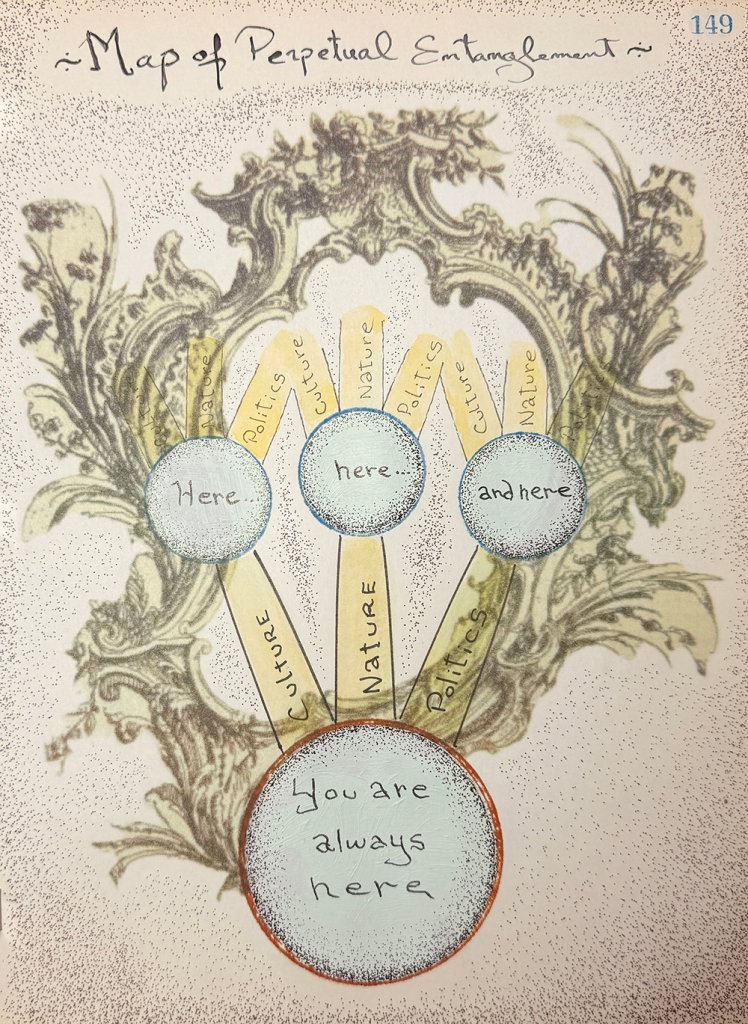
Legend:
“To know the universe itself as a road, as many roads, as roads for traveling souls.”
— Walt Whitman, from Song of the Open Road, stanza 13 The unquiet mind and frustrated desire are the muleteers on this fool’s journey that inevitably runs round to its starting point. Entangled are the roadways and boreens of culture, nature, and politics. Dangerous intersections and lively gathering places they be. An existential map, then, a guide to the interior gets you only so far. Follow its signposts in perpetuity. You must. The journey is itself a vital force.
About:
Greg Slick is a visual artist, independent curator, and museum educator based in Beacon and Newburgh, NY.
Time, history, archaeology, and anthropology play major thematic roles in his work.
Solo exhibitions include Depth Perception at the Garrison Art Center, Garrison, NY; Old Bones and Broken Stones at No. 3 Reading Room & Photo Book Works, Beacon, NY; and Opened Ground at the Seligmann Center, Sugar Loaf, NY. His work was featured in the group exhibitions The Librarian at The Lockwood Gallery, Kingston, NY; Birds of a Feather at Ethan Cohen Gallery/KuBe Art Center, Beacon, NY; The Longue Durée at Holland Tunnel Newburgh, Newburgh, NY; and Collective Expeditions at both BSB Gallery, Trenton, NJ and SUNY Ulster, Stone Ridge, NY. Other group exhibitions include Take Back the Walls at the Rochester Contemporary Art Center, Rochester, NY; Painting in the 21st Century, at Site:Brooklyn, Brooklyn, NY; and Time Travelers at The Samuel Dorsky Museum of Art at SUNY New Paltz, New Paltz, NY. Slick’s work was included in UNI-VERSE Poetry-Prints-Proofs by Visionary Humans, Battery Journal Publishing, Anna Ehrsam and Katherine Jackson, editors.
Slick is the founder and co-curator of the artists’ collective The International Society of Antiquaries.
Dec 3: Jonathan Hartshorn

Legend:
this is a noise-signal-anomaly experiment-
About:
Feature Inc. NYC Show
Instagram
Artist Interview
Dec 4: Lindsey Fromm
Legend:
Horse Bypass Cathedral, digital collage and sacred site
I began hiking to Horse Bypass Trail (365) regularly in 2020. The familiarity of the path was regulating at a time when I felt like I was at the bottom of a well.
We found one special pile of large rocks in Albuquerque’s Sandia mountains foothills and returned often. There are many similar sites there, but this one is ours.
My mind was always haunted during the hike up. Arriving to the site, blood pumping and a breeze on my face, all that darkness fell away into a liquid state of being fully present. I felt safe and comforted by the granite towering around us, like a womb, like a cathedral.
To find it, drive east to the very top of Indian School Road where it ends in a parking lot at the base of the mountain. Walk south to find the 365 trail. You will head south first, then the trail will wind up towards the northeast.
There are guideposts along the way.
These are features you will encounter at the cathedral:
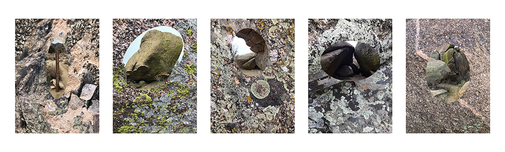
Here I offer a title for each site and a card pulled from the oracle deck Poesis by Andrea Wan with an excerpt from a corresponding poem by Megan King.
Left to right:
1. Guidepost: UNKNOWN, “It takes a heart faithful and willing enough to walk through/ the door of
a darkened room”
2. Tower: LISTEN, “A portal into new worlds opens for those who learn/ to be receptive to all the ways
life speaks to us.”
3. Nave: COURAGE, “Your courage echoes through the mountains./ It is the single dew drop that
sustains an entire desert.”
4. Altar: HUMILITY, “this is exactly the shape I need to be/ this is the experience that belongs to me”
5. Crossing: EXPLORE, “stay as you learn what it means to be you./ Don’t run, stay.”
About:
I am a mother, artist, teacher, and organizer living in Albuquerque, New Mexico. I am interested in how the
sacred presents itself in our everyday experiences, bringing joy to both the mundane and the extraordinary,
and providing constant opportunities to reflect, change and transcend.
Lindsey Fromm, 2025
https://andsoforever.com/
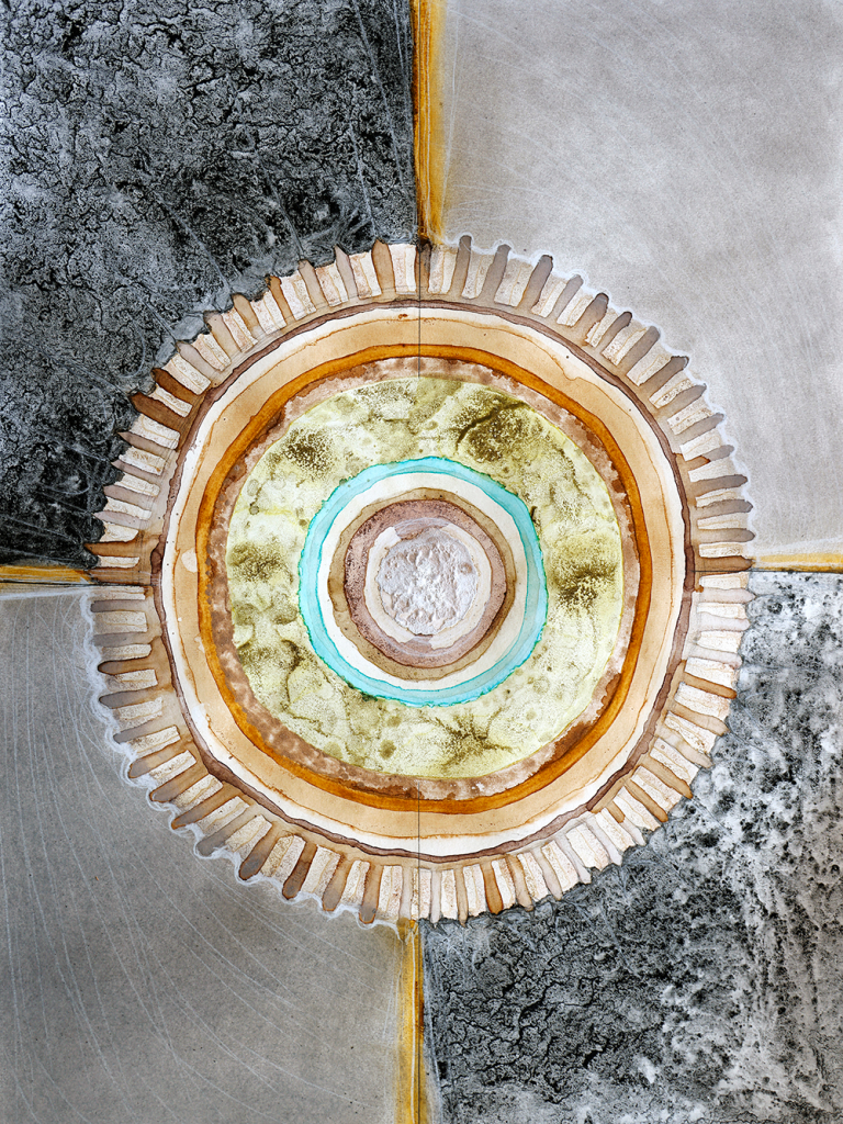
Dec 5: Elia Gurna
Legend:

from A Guide for the Perplexed, E.F. Schumacher, 1977
About:
Dec 6: Angelika Rinnhofer
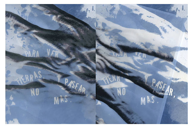
Legend:
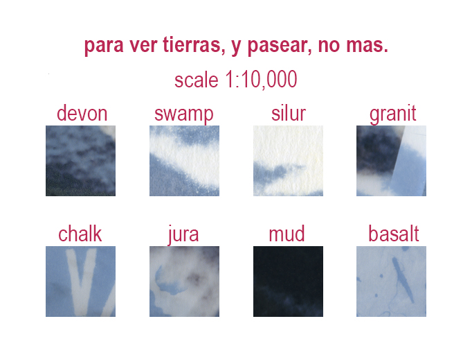
Alexander von Humboldt was a German naturalist and explorer. During his travels across the Andes, he encountered a German hermit living high in the Peruvian mountains. The recluse had renounced not only all contact with people but also his native language. When Humboldt asked him about his life, the man replied, “Para ver tierras, y pasear, no más.”
About:
Dec 7: Christopher Albert
Legend:
My Dreams Are Festooned With Ample Secret Storage And Undiscovered Bonus Rooms
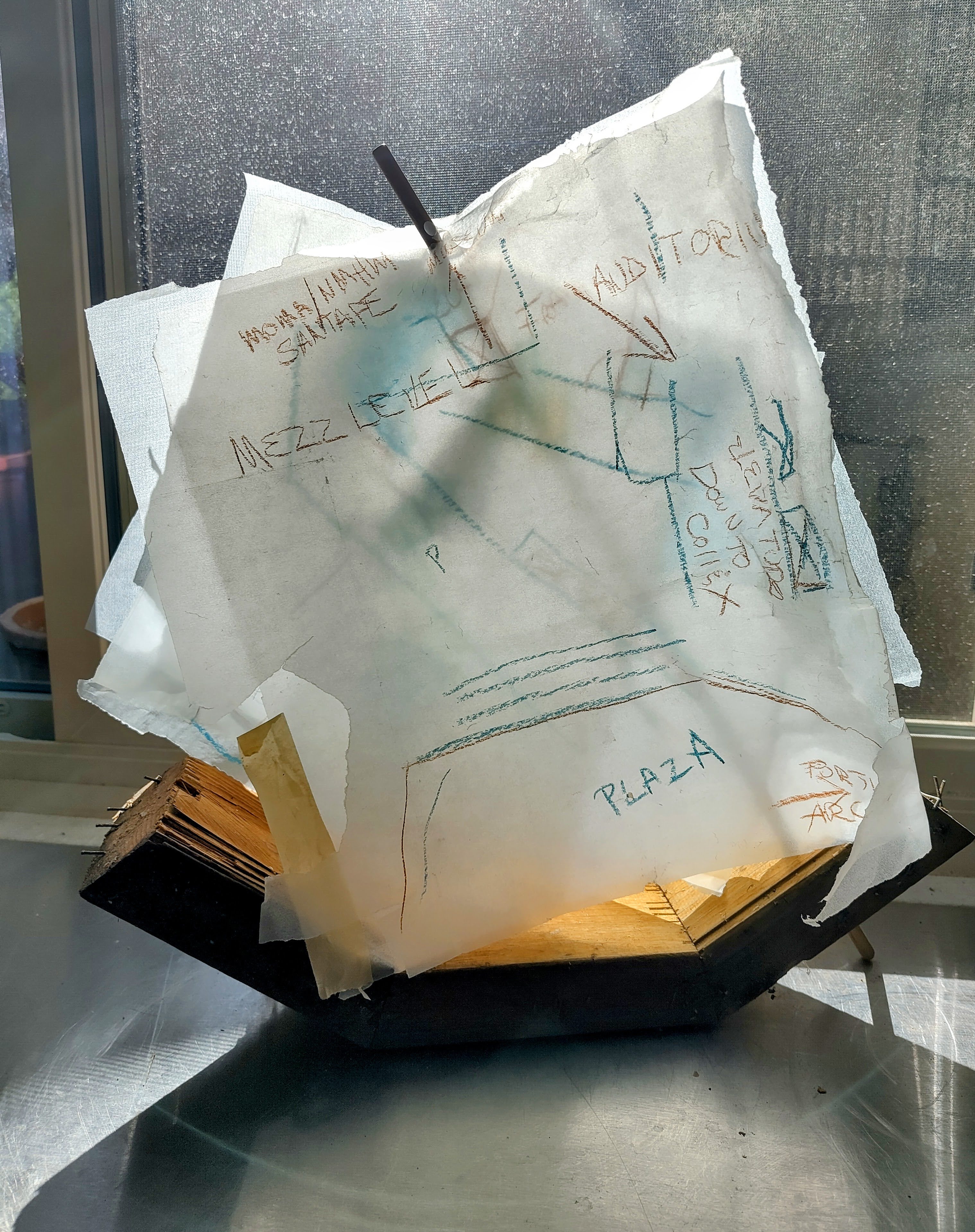
pencil, pastel on glassine
Circa 1985, on a middle school spring break, the family took a trip to Lake Powell.
Not much more than ten minutes after casting off from the northern most marina in our rental houseboat, the navigation map was thrown out the window by a gusty wind.
In the spirit of forward seeking exploration, instead of turning back into the very near and known to procure another map, we charged forth, armed with the vague recollections from the very limited exposure to that map. Staying, we hoped, to the main spine of the lake, we came upon the next marina a day later, refueled and grabbed a map that was more carefully kept.
This memory only recently reemerged as a salient rhyme to a current focus of mine/mind which is attempting to map the sites of my night dreams.
In recent years, I’ve come to recognize there exists a stable infrastructure of dream settings within my brain. The unassailable consistency, initially a little unnerving, has made me feel certain that there is an finely defined mental archive of models that are accessed and rolled out whenever the action calls for them.
I’ve only just embarked on the effort to record these sites that have morphed and fused the physical spaces they represent into the recognizable night terrain they have become. But, as with navigating a boat after your map flies out the window, these efforts are still sketchy at best. In time I hope to suss them out and see if they all stitch together in something more than just a back-lot of my unconscious.
About:
Christopher Albert lives in ABQ. He births things like this Xmaps project.
Dec 8: Lacey Chrisco
Legend:
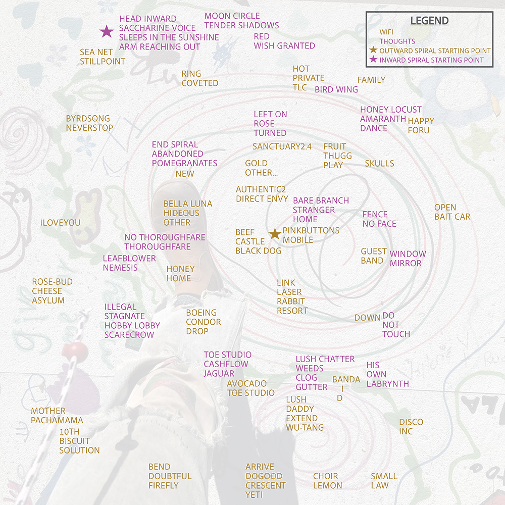
Wifi Mind Map
This is a map of both fragments of wifi network names and my own thoughts and observations. Both were recorded as I walked in a spiral pattern outward from my house and then back inward to my house.
1. Starting from my house, I began walking in a clockwise spiral pattern. Periodically, I looked at the wifi signals and took a screenshot of them. On the map, the starting point is marked in the center with the yellow star & text.
2. Once I felt ready to head home, I put my phone away and pulled out a notepad and paper. I continued walking in a clockwise spiral back towards my house, in most cases retracing my steps. I sometimes wrote exactly what I saw and other times thoughts that came into my head. On the map, this starting point is in the upper left with the purple star and text.
3. At home, I created erasure poems with both sets of data. For each wifi screenshot I erased the text down to a few words – each grouping of yellow text is created from one screenshot of wifi.
4. I mapped out each short poem to create this final map. This project was inspired by labyrinths, randomness and synchronicity, dadaism, obsession and addiction to screens, and the dichotomy of the internal and the external world.
About:
Lacey Chrisco is an artist living and working in Albuquerque. She uses photography and conceptual art to explore themes of fragmentation, transformation, and mischief. She formerly served as the Assistant Art Curator at Albuquerque Museum and co-curator of the Inpost Artspace. Her personal website is under construction, but you can explore one iteration of her Glass Beach project here.
Dec 9: Caitlin Ainsworth
Legend:
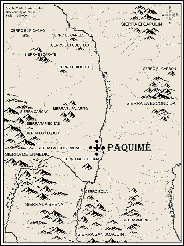
Paquimé and its Environment
Environment shapes our lived experiences. It constantly intrudes on our awareness, forcing notice and actively shaping behavior in the short and long-term. Maps allow us to capture not just the technical components of an environment, such as geology, hydrography, soils, and vegetation, but also some of our own subjective impressions.
This map depicts the environment surrounding the pre-Hispanic archaeological site of Paquimé; a UNESCO world heritage site located in northwestern Chihuahua, Mexico. Existing in the shadow of the Sierra Madre Occidental, it is a landscape dominated by mountains and nourished a complex tapestry of rivers, streams, and washes. It was against this backdrop that Paquimé grew and flourished from the twelfth to fifteenth centuries. It is a landscape I have found myself returning to time and time again for my own academic research. And in all those years I have never failed to be awed by those magnificent peaks. Cartographers have many tools for illustrating topographic relief from the simple topo lines to complex 3D elevation models. I chose a hand-drawn style, in stark black, to give greater visual weight to the mountains and peaks and emphasize their importance. The major rivers are illustrated by solid lines; seasonal and ephemeral waterways by dashed. Paquimé itself is symbolized by a simplified illustration of one of its architectural features: el Monticulo de la Cruz (the Mound of the Cross).
About:
Caitlin Ainsworth is an archaeologist, museum professional, full-time graduate student, and parttime dabbler in cartography.
Dec 10: Claudia Scalise
Legend:
Get Lost: Inner Travels
Inspiration: a much longer list exists..
All kinds of TRAVEL
*My parents, my brother
*Lovers
Drawing
So many books and movies and shows and conversations
Food
George Brooks and Thales
CGJ
Cats
Knitting
Michael Sugrue and Plato
Dreams
Umberto Eco
*Teachers and Students
Plants
*Friends
Music
Coffee
Richard Wolf
Aristotle
Now
Wine
Cory Doctorow
Work
Stuff I’ve collected
Memories
Ideas
Painting
About:
Claudia Scalise was born in California, and has a studio in Miami. She has taught art for 27 years.
Dec 11: Peggy Nolan

Legend:
Gaze
…..everything in my house staring back at me
About:
Interview w/ History Miami
Interview w/ Vogue
Dec 12: Chandler Wigton
Legend:
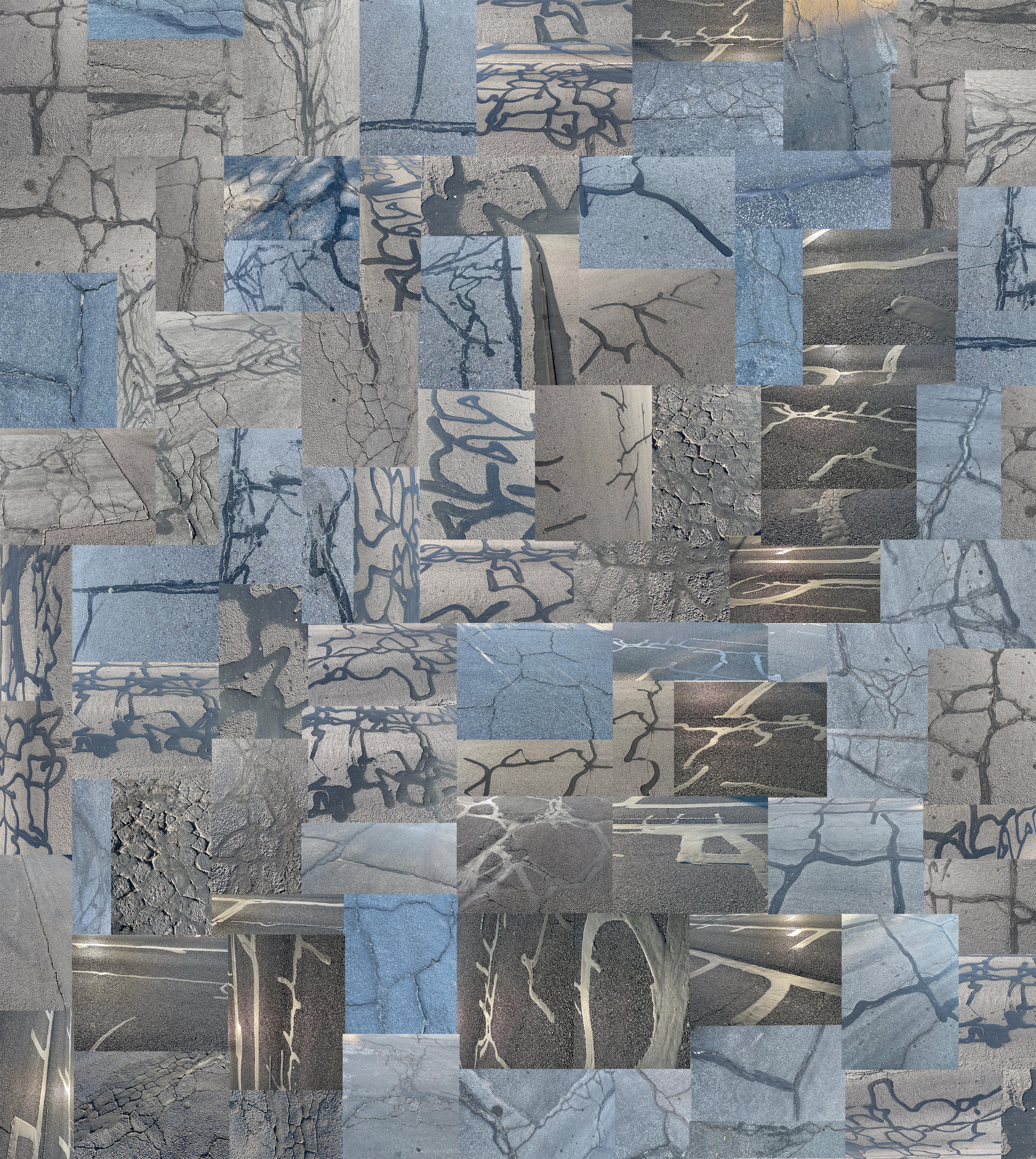
Patches and Markings
During the pandemic, like many people, I walked a lot in my neighborhood. I would often use a map app on the phone that could track my route so I could see how many miles I walked. I liked looking at the actual line of the tracking as if it was a little drawing that I made by walking around the neighborhood. While I’m not super crazy about technology tracking our every move, I do like the concept of walking being a form of drawing. These walks would often involve me starting a specific album on my phone, walking aimlessly from my front door, and trying to be back at the exact moment the album ended, taking pictures of random things on the street as I went. There were spatial and temporal elements working together.
This map project has a similar spirit. I spent an afternoon walking around my neighborhood taking pictures of two things everywhere I saw them, spray-painted markings on the asphalt, and cracks and patches in the asphalt. I’ve always been attracted to the spray-painted markings that denote sewer lines, gas lines, and whatever else on the street. It’s a utilitarian scribbling that is meaningful to some people and endlessly interesting to look at. Likewise, the cracks that form in asphalt, and the patches that get put on, are sometimes staggeringly beautiful to look at, especially in certain light. The line quality and painterly aspects are abundant. As a group, these are marks that are intentional, and follow structures that are underneath the surface, or are created through forces outside of people’s control. In terms of the spray-painted marks, they are a guidance system so we don’t lose track of what is underneath the surface. In terms of the asphalt patches, they are marks that follow a force of nature, and attempt to hold something in place that is falling apart.
The map of the walking route that I took was made using an app called on X. The teal line is the actual route, I abstracted and repeated the map a little bit to emphasize the angularity of the route one has to take in a city with blocks, as opposed to the lines created on a map if you were to just wander in the woods for the same amount of time for example.
About:
Chandler is an artist and educator who lives and works in Albuquerque, NM. Chandler holds a BA in Studio Art from Fort Lewis College in Durango, CO, and an MFA in Painting from Tyler School of Art in Philadelphia, PA. He currently teaches in the art department at Central New Mexico Community College. In his work he is interested in improvisational abstraction, drawing, collage, printmaking, and bookbinding.
chandlerwigton.com
WaveModes: An exhibit by Chandler Wigton
Dec 13: Chris Bratton
Legend:
Re-mapping Raphael’s Madonna Della Seggiola in the language of domestic photography. A once great friend said, “friendship is shining light on each other.” When someone touches your life in some way, we use a camera to take a picture as a lasting symbol of paths crossed. Through each snapshot We chart our relationships, emotional geography, and make lasting records of the ordinary moments that become extraordinary in hindsight. The most important of which, we put in big fancy frames and hang them in our homes.
About:
Chris makes art because he loves it. He has no web page or media presence. It is unlikely you will wander into a show of his work. He is more likely to be seen hanging yours.
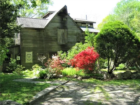
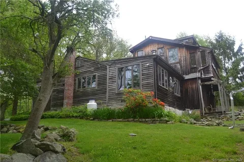
Dec 14: Sharon Butler
Legend:
37 Pequotsepos Center Road, 2025,
crocheted wool yarn, 18 x 17 inches
The old house at 37 Pequotsepos Center Road was built in the square area at the lower left corner of the crocheted map. Broken stone walls surrounded the sloping, pastoral property. It comprises two acres that have shadowed me for thirty years – land in Stonington, Connecticut, that I fell in love with and bought in 1994. While living there, I had a great run of success – a tenure-track teaching position, vigorous NYC gallery representation, a baby girl, and more. The land, which was the subject and muse for many paintings, seemed to love me back. I lost it during a difficult divorce ten years later. For years after I moved out and moved on, I still felt a deep connection to the place and hoped to buy it back one day even though the current owner also loved it fiercely and had said she would never let it go.
A month or two ago, more than twenty years after the divorce, something unspeakably tragic happened in the woods surrounding the house that made me rethink the Pequotsepos energy. I started digging into the property’s past and unearthed hints of a curse worked by history. In the 1600s, these two acres and plenty more were granted to John Gallup, one of Stonington’s founding fathers, as payment for his success in “clearing” the land of Native Americans. The house, the quarry, my old barn studio – they may have been built directly atop a Pequot burial ground or another tribal holy site, or displaced Pequot families expelled or worse. Looking back, I discovered that the house had delivered unhappy outcomes to several of its owners. Was it perhaps haunted? I pondered the possibility during many a fitful night, and, only semi-consciously, began to crochet this woolen map.
About:
Sharon Butler is a painter and the publisher of Two Coats of Paint. She lives and works in Long Island City, Queens, NY.
Sign up for her monthly newsletter at Sharon Butler Notebooks and Instagram at @sharon_butler.
In January 2026, look for her work on view at McBride/Dillman, New York, NY.
Dec 15: Peter Acheson
Legend:
The big idea is that we navigate the “.field” by means of participative signals – like everything emits waves which overlap and spread as we inhabit Place.
About:
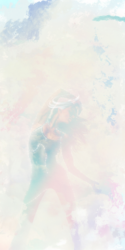
Dec 16: Oliver Endahl
Legend:
About:
Oliver Endahl is a photographer and artist based in the American southwest. He is best known for his critically acclaimed “Ballet Zaida” art project, which helped launch the dance photography movement on social media, transforming how dance is seen and shared.
A former professional ballet dancer himself, his knowledge of dance technique combined with being the first dance photographer on Instagram, propelled his early photographs and reputation for striking imagery. His work has been featured in major publications including Vogue, Cosmopolitan, People, Elle, and Dance Magazine, among others. Oliver has also created commercial campaigns for companies such as Etsy, Free People, Jamba Juice and more.
The human featured in the work is “Casimere Jollette”
You can view and follow Oliver’s work through his website and social media.
https://www.instagram.com/balletzaida
Dec 17: Carol Murdock
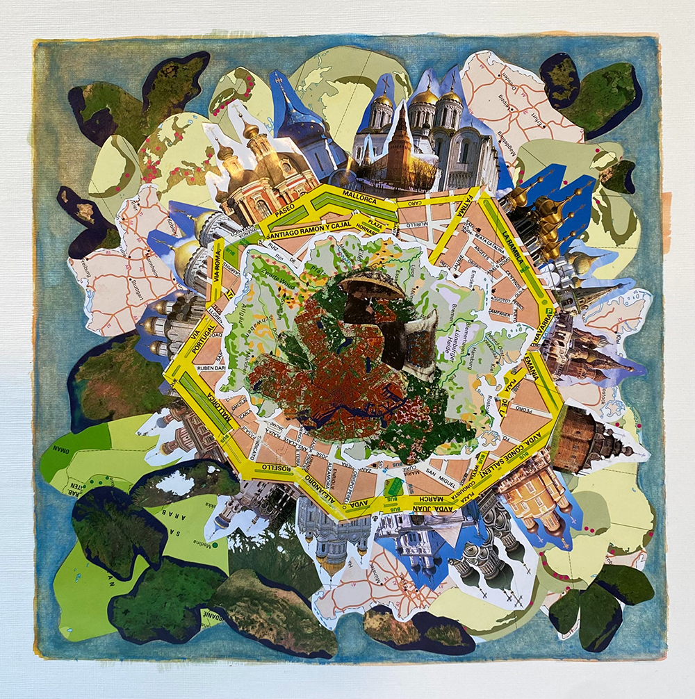
Legend:
These Are Days
Analog collage utilizing photographic imagery from “Moskou” Capitool Reisgidsen, 2000 edition; De Junior Bosatlas, Zesde Editie, Noordhoof Uitgevers; “Zaandam” by Henk Poppen, 1995; Mallorca tourist map; gouache, acrylic pens, Japanese rice paste, and acrylic paper. 31 cm x 31 cm
This work represents a gateway for mentally mapping nostalgia through imagery, music, and song lyrics.
These are days
These are days you’ll remember
Never before and never since
I promise
Will the whole world be warm as this (!)
And as you feel it
You’ll know it’s true
That you are blessed and lucky
It’s true that you
Are touched by something
That will grow in you, in you
These are days you’ll remember
When May is rushing over you with desire
To be part of the miracles you see in every hour
You’ll know it’s true that you are blessed and lucky
It’s true that you
Are touched by something
That will grow and bloom in you
These are days
These are the days you might fill with laughter until you break
These days you might feel a shaft of light
Make its way across your face
And when you do you’ll know how it was meant to be
See the signs and know their meaning
It’s true
You’ll know how it was meant to be
Hear the signs and know they’re speaking to you, to you
10,000 Maniacs
“These Are Days” from their 1992 album, “Our Time in Eden”
Songwriters: Jerome Augustyniak / Natalie Merchant / Robert Buck
About:
Dec 18: Moira Garcia
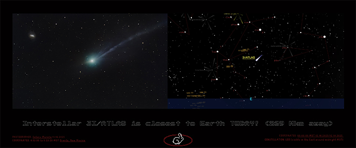
Legend:
167.167492 million miles away
Digital collage
Interstellar 3I/ATLAS is closest to Earth TODAY! (269 Mkm away)
Left Image:
Photographer: Satoru Murata 11.16.2025
Coordinates: 4:53:50 to 5:23:20 MST Grants, New Mexico
Right Image:
Coordinates: 00:00:00 MST 12.18.2025/12.19.2025
Constellation: LEO (visible in the East around midnight MST)
Rabbit Hole: Selection of 31/ATLAS topics on YouTube
About:
Moira Garcia
Instagram: @moira.garcia.art
Xochiyotl : Florescence – solo show in Santa Fe at Hecho a Mano Feb 6-Mar 1.
Dec 19: Penny Young
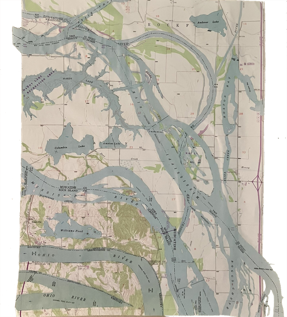
Legend:
Maps for me describe the world not as it is seen but as a graphic way to interpret the world. The edges of water and the ridges of mountains, the expanse of plains. Then the human alterations of maps in roads and aqueducts and buildings and counties. In constructing this map, ROCK F, I noticed how counties and states are determined by the shores of the water, or the midsection of the rivers. I don’t live in such a state, mine is square and surveyed in some less natural way.
I am collaging water, twice pieces of the Ohio river and the Mississippi occur, then lakes for recreation and creeks and one long Missouri River segment underneath. I wish to add water in my dry state, New Mexico, so I filled the space with bodies of water from many places, like an Army Corps of Engineer’s project gone awry.
About:
Penny Young is a sculptor, poet and arts educator. Her practice includes paper and ceramic sculpture, installation, drawing and kinetic works. Ms. Young graduated from the University of California Santa Barbara, and received her M.F.A. from California State University Northridge.
Penny has been an artist-in-residence at Mt. St. Mary’s College in Santa Monica, California and at the Armory Center for the Arts in Pasadena, California. She was the Chairman of the Art in Public Places Committee for the City of Burbank, and consulted on set as an artist and prop-maker for Hungry Man Productions and the HBO Series Six Feet Under.
She has taught at Ceramics and Drawing at College of the Desert, Palm Desert, California State University Long Beach and Northridge and currently teaches at Central New Mexico Community College.
Penny currently lives and works in Albuquerque, NM creating large-scale paper mache objects, ceramics, ink drawings and writing poetry.
https://pennyyoungo.com/home.html
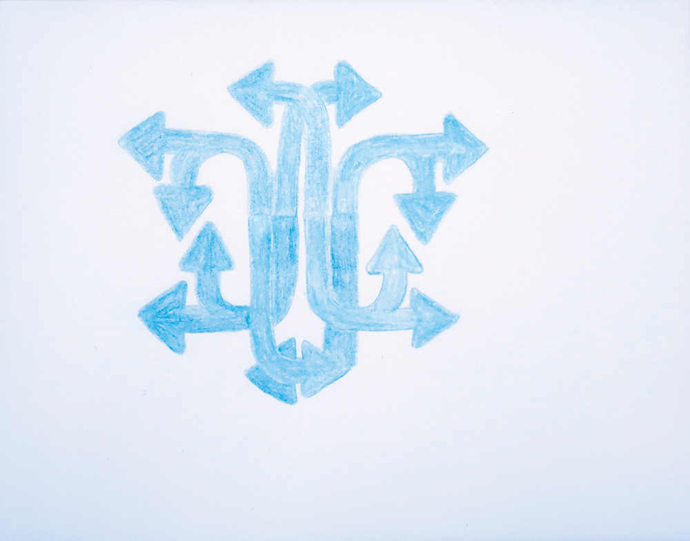
Dec 20: Peter Iannarelli
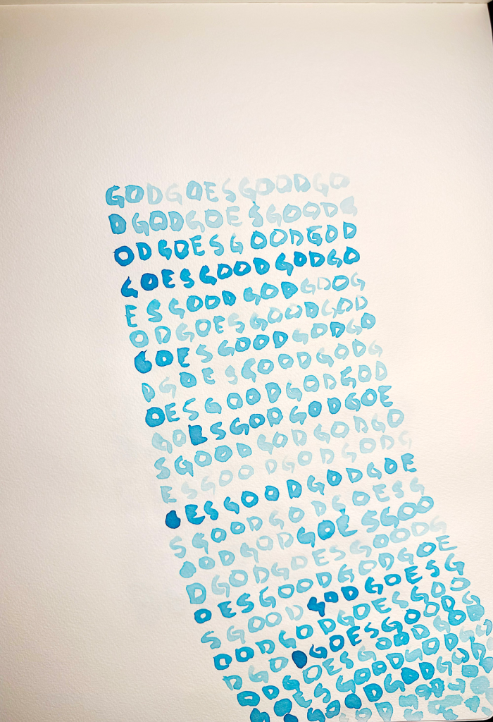
Legend:
God Goes Good
watercolor
In these pieces, I was interested in words as meaning, but was surprised by their visual impact particularly how they became directional
About:
An unearthed audio clip of Peter talking about the Found Object.
Dec 21: Toni Gentilli
Legend:
Compass Rose, 2025
Mixed media
We are at the threshold—on the edge of uncharted territory, neither here nor there, ensconced in the liminal, suspended in mystery, shrouded by the unknown—we are between worlds now. A place of vulnerability; a dizzying swirl of simultaneous endings and beginnings; a place of great possibility.
Today, on the celestial threshold that is the Winter Solstice, I share with you a conjuring of sympathetic magic in the form of a navigational tool.
I created this compass rose from familiar earthly materials to help orient myself in this unfamiliar territory.
May we all find our way out of the shadows and back to the light. So mote it be.
1) Salt (halite, sodium chloride, NaCl). Gathered from the edges of a warm spring erupting from the floor of an ancient (320 million year old!!!) inland sea that once covered most what is now New Mexico. A precious offering from a tiny portal animated with gurgling water and minerals from deep within the land, heated by the swirling energy at the earth’s core; chthonic, molten, ever-changing.
2) Red Dock (Rumex aquaticus). Tannin and oxalic acid from the roots of a self-pollinating, hermaphroditic plant who thrives at the margins of land and water, often found along acequias. A potent concentrator of tart, astringent medicine from a being not of this place, but who freely contributes their gifts to others, if only you look beneath the surface and open yourself to unfamiliar flavors.
3) Yerba Mansa (Anemopsis californica). A distinctive, aromatic, medicinal paleoherb nicknamed “lizard tail” for their stolons. These asexual reproductive organs spread clones of the parent plant through horizontal above-ground branching. Like a lymphatic system, this network of connected individuals filters and balances fluid distribution across an otherwise hot, arid landscape.
4) Creeping Barberry (Mahonia repens). A low, rhizomatous evergreen plant with spiky leaves and electric yellow hermaphroditic flowers that give way to purple berries cloaked in a haze of east. Anchored by roots as bright yellow as their flowers, these xanthous tendrils contain berberine, a cooling, calming, anti-inflammatory compound. I think we could all benefit from soothing grounding energy right now.
5) Verdigris (cuprum aceticum, copper acetate, Cu[CH 3 Coo] 2 ). A section of an old pipe transformed by the pungent byproduct of fermenting aerobic bacteria who oxidize ethanol into acetic acid, along with water, air, and time. An unnaturally bright, aqueous hue loosed from the confines of technology employed to constrain and conduct water in unnatural ways. Dissolution is an inevitable part of transformation. Here’s hoping what we make of this process is more beautiful and precious than what we started with.
6) Rio Grande Cottonwood (Populus deltoides wislizenii). Crimson catkins from the male cottonwood tree behind my studio blanket the earth each May after releasing their pollen. The wine color of these flowers is as ephemeral as their bloom, turning purple when dried, then green, gold, and pink in the dye bath. A consummate example of the wonder of complexity, nuance, mutability, and divine timing.
7) Clay gathered at the Rio Grande’s edge, in the two-million-year-old bosque at the base of a 30-million-year-old continental rift, one of five still active. A river that gathers and refines this clay in waters that flow from many origins and the singular universal source. A once wild entity, braided into the landscape and tethered to the rhythms of the moon, is now a fixed channel that we turn off and on like a faucet.
8) Iron (Fe) coaxed from steel cables once interwoven among the jetty jacks—bellicose structures installed by the Army Corps of Engineers along the banks of the Rio Grande in the mid-twentieth century for flood and erosion control. Rendered moot by subsequent over- engineering of the river, a few still stand testament to the pervasive desire to forcibly control living entities to serve our purposes rather than learning how to flourish alongside them.
9) Sunflower (Helianthus annus). Phytoremediators that can absorb radioactive contaminants from the soil. Reminders that there can be beauty in the breakdown.
10) Western Antler Lichen (Pseudevernia intensa). A symbiont who grows on the bark of coniferous trees and is comprised of the photosynthesizing algal species known as Trebouxia jamesii in an otherwise fungal body. Together they form a natural air filter and potent respiratory medicine. As above, so below.
11) Prickly Pear (Opuntia spp.). Pressed from the fruits of a ubiquitous cactus that thrives in challenging environments. May its diversity, beauty, and sweetness permeate us all with the wisdom of an overlooked and undervalued being.
12) Three Leaf Sumac (Rhus trilobata). From the sticky red berries on a shrub given a racist nickname that belies the deep ecological knowledge, ingenuity, and relationality of the Indigenous women who have stewarded these lands since time immemorial.
13) Rocky Mountain Beeplant (Cleome serrulata). Also known as Indian spinach, this package of pigment was made by a Tiwa friend. Used to both paint designs on pottery and nourish those who paint them. A versatile being
About:
Toni Gentilli
tonigentilli.com
Instagram: @phytomorphologie
Dec 22: Nicki Stager & Angelika Rinnhofer
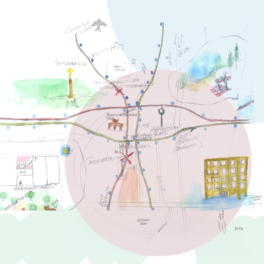
Legend:
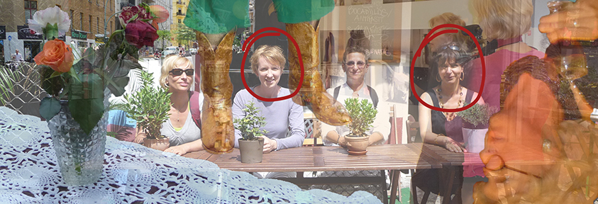
Every few years, around October 25, Nicki sends me a text. She did this year, too, and we decided to talk, which resulted in a lengthy conversation. Nicki and I earned our MFAs in Berlin, where we spent two summers. At one point, Nicki mentioned that a friend asked her about Berlin and how to get around the city. She tried to draw him a map only to realize that her memories no longer added up to anything precise. We decided to draw memory maps of Berlin and layer them together. Nicki remembered neighborhoods (circles), and I remembered details. The legend shows us with two friends who were also in our program. Everything else
is fragments, faded snapshots of our time in a city that seems a world away.
About:
nickistager.com
angelikarinnhofer.com
Dec 23: Kate Fraher
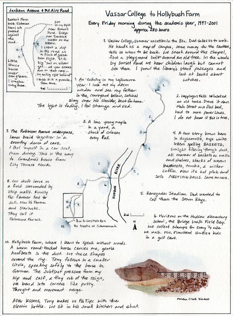
Legend:
Watercolor, thread and ink on paper, 2025
In August of this year I moved back to the Hudson Valley, where I grew up, after 13 years away. Since returning I find myself slipping through layers of personal history linked to place in a disorienting symphony. Significant and repetitive events mix with trivia and sense memories in a fog of associations hovering over and through the landscape. I find the symphony most engrossing while driving. Time slips its mooring and I feel an echo of myself at 16, 22 or 30 just by glimpsing a certain unchanged house or a singular tree that figured regularly in a past commute. The echo announces itself in a nostalgic sweep of feeling, a flare of shame or disgust, a little marble of inane information…
This is an attempt to catalog how my mind relationally maps the world around me, how I make physical shapes on the landscape in my routine migrations and pin meaning and anecdotes to landmarks with varying degrees of awareness and relevance.
From 1997 to 2001, I studied at Vassar College where my father was an administrator. Every Friday morning he would lend me his car to drive an hour back home for a dressage lesson with the horse-whispering riding master I’d been training with for several years. I chose this commute because it’s been one of the more powerful echo chambers I’ve found since returning.
The story of this route is at least partially about what I was unwilling to let go. Maybe that’s the story of this whole experience
Dec 24: Rob Murdock
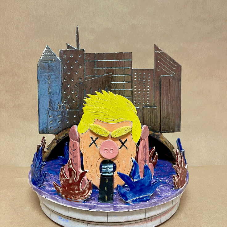
Legend:
The Perilous Road Back
glazed earthenware ~30 x 30 x 30 cm
In his farewell address to the nation back in 1989, outgoing President Ronald Reagan borrowed the metaphor of a shining city on a hill to communicate the promise of American Exceptionalism. He imagined a place “teeming with people of all kinds living in harmony and peace…open to anyone with the heart and will to get here.” As naive as this sounds, Reagan’s shining city on the hill is the America that I believed in. I was 17 years old when Reagan left office. My America welcomed hard-working immigrants with open arms. My America was the land of limitless opportunity and Horatio Alger. My America beat the Russians at ice hockey, launched the space shuttle and won the Cold War. Right?
Turns out my America WAS exceptional for privileged, middle-class White cisgender straight boys like me…just maybe not for anyone else. And maybe not for any of us anymore. Empires rise and then they fall…what are we supposed to do about it? Cling to our faded grandeur in hopes of slowing the decline? Drag the rest of the world down with us? Or just perhaps, reimagine and retool to deliver something even better than the original? The long national reckoning has begun, but it has lately stalled. Sadly and stranger still, the coin-op ruling regime’s impulse is to look backwards toward some fun house mirror version of an America even older, even more flawed than Reagan’s 1980s. The road backward leads to a dead end — an outdated idea of a place that never actually existed. We’d do better to turn toward the future and map a new path.
About:
Rob Murdock is one-half of Unusual Beast (instagram: @unusual.beast), an art collective based in The Netherlands. He spent a career producing millions and millions of consumer products in factories all around the world. To make amends for this, his art practice focuses exclusively on hand-built, one-of-a-kind pieces fired in small batches at his Haarlem studio.
Dec 25: Marc Wilhite
Terres inconnues (Unknown lands)
Tonight the moon leaves
that startling impression
as if someone’s punched a hole
in the night sky,
with a hole punch I mean,
and light from the other side
seems to rest there
on the rim of the hole,
revealing the thinness
of the boundary
that separates us.
Legend:
In the basement of the Château Frontenac, in Québec City, you can find a wonderful map bearing the title of this poem.
About:
Marc Willhite is an artist living in Denver, CO.
Dec 26: Megan Kate Nelson
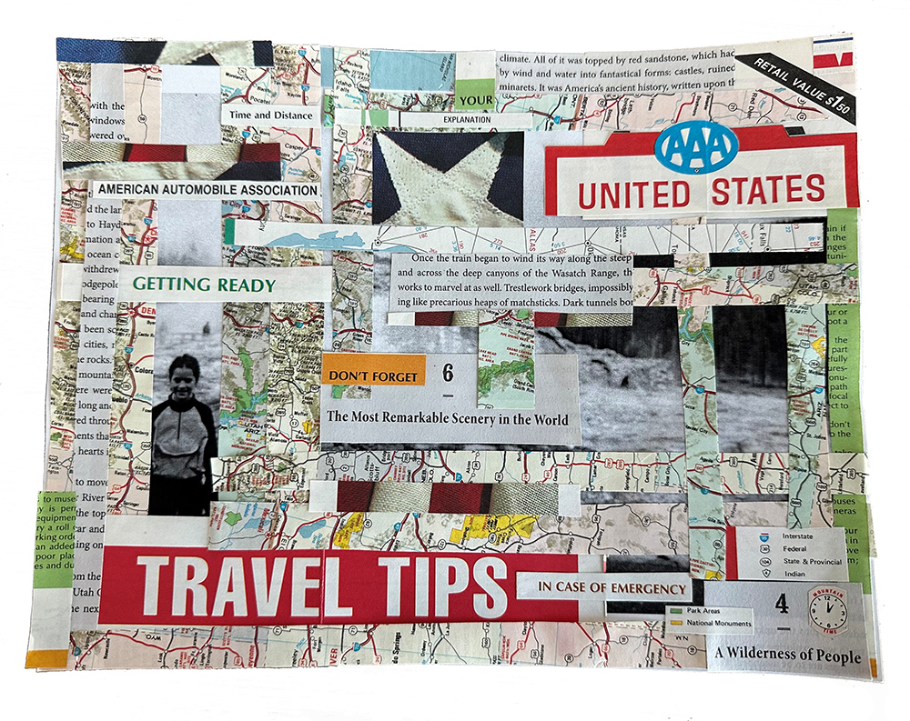
Legend:
DON’T FORGET
MATERIALS: 1982 AAA USA ROAD MAP, PRINTER PAPER, BOOK FRAGMENTS, GLUE
During the summer driving vacations of my youth, the prized seat
was the shotgun. Not because of the view out the windshield or the
access to the glove box, but because whoever sat in that seat had
control of the road map. Whoever sat there could give my mother or father directions, and they would follow them. At what other time in the life of a child in the 1970s and 1980s was this a possibility?
Control of the map gave me power. It also gave me a real sense of
the landscape outside of the car, and how we were moving through it. It is not really a surprise, then, that when I became a historian much later in my life, I had a particular interest in the ways that we interact now and have interacted with landscapes of the past.
When I write my books, I visit the places that I write about. I give
readers a sensory experience of those places as a result. And I
make my own maps, tracking my protagonists’ movements through the landscape.
“Don’t Forget” reflects these different experiences of mine, both past and present—and how maps have been, for me, a way to engage with both time and space.
About:
Megan Kate Nelson is a historian, cocktail enthusiast, and the author of five books, including the forthcoming The Westerners: Mythmaking and Belonging on the American Frontier, as well as The Three-Cornered War (2021 Pulitzer Prize finalist, History) and Saving Yellowstone (2023 Spur Award, Historical Nonfiction).
Born and raised in Colorado, she now lives in Boston with her husband and two cats.
Dec 27: John Dooley
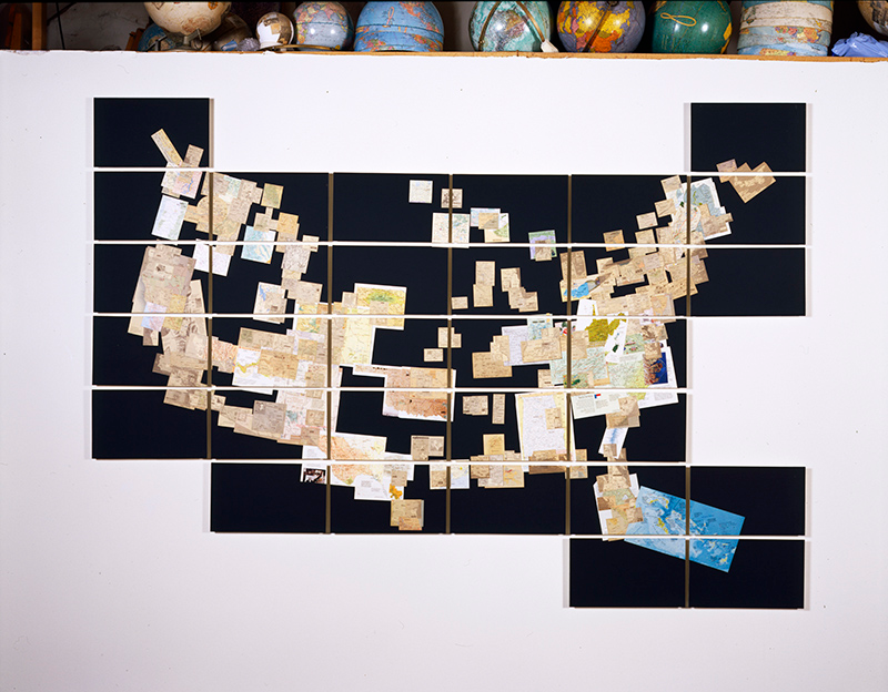
Legend:
US, 2003
Newsprint and magazine print on paper, wood panels
6’ x 10’
———
My work deals with re-contextualization. I am interested in forms and systems that have been established and transformed. I’m interested in the forces that transform these systems and the fact that the representations of these systems and their transformations often then take on a life or meaning of their own, long after the meaning of the thing they represent has lost its original function.
In describing the process I employ to create the artwork in this exhibition, I often picture myself kneeling at the banks of a stream. Through the stream flows the various aspects and products of our cultural production. I enjoy reaching into that stream, pulling out selected bits, reconfiguring them, and then setting them back into the flow.
In my own artwork I often employ sculptural and graphic strategies such as mapping, accumulating, sorting, and gridding in order to explore and express this type of re- contextualization. The forms and systems I am interested in exploring and depicting have often already been subjected to this type of representation, and my work is then a second- or third- generation depiction of a subject. A picture of a picture of a picture, if you will.
John Dooley
June 2003
———
This text is a brief artist statement my dad wrote to accompany his August 2003 show Paper at the Roswell Museum and Art Center. The piece pictured above, “US” (2003, newsprint and magazine print on paper, 6’ x 10’), was included in the show. He made the body of work for this show during his time as a grantee of the Roswell Artists in Residence foundation (RAiR). We (my mom, dad, brother, and I) spent a magical year in Roswell exploring the high plains and desert and making art. Roaming the landscape became an important part of our life in New Mexico and it was foundational to my own practice as a photographer: I still spend a lot of time wandering in order to make bodies of work about matters (and manners) of land use.
I love this photograph of US because it was taken in his Tribeca studio when we returned to New York after the end of our year at RAiR. I’m picturing all the panels of this piece being carefully packed in Roswell, tracing our route across the country, and then being unpacked and re-installed in New York to be photographed. I love that you can see—at the top of the frame—a sliver of the storage loft in his studio, and at least a dozen globes in various states of disassembly and collage.
Paloma Dooley
November 2025
About:
John Dooley was an artist working in sculpture, collage, and video. He was born in Sacramento, CA in 1956 and earned a B.A. in art from Humboldt State University. In 1991 he graduated from RISD with an M.F.A. in sculpture and moved to New York. He lived and worked in New York City until his death in 2011.
Dooleygallery.com
Dec 28: Vybrainsee
Legend:
Subject: XMaps the Spot — a sound map by Vybrainsee
Maps often infer a frequency of movement- a rhythm – and every rhythm draws a line through our bodies.
X Maps the Spot is a cartography in sound — a groove designed to align pulse with place, the moment in motion.
Where conventional maps trace roads and rivers, this one traces vibration — a living current you can feel in your chest, your hips, your breath.
Through beats and bars, we map the invisible: the kinetic thread that ties us all into time and space. The kick and snare a coordinate, the bassline a path.
It’s navigation and also it’s communion. A way of finding ourselves by moving with the groove.
Xmaps the spot where your body syncs with the universal metronome.
Travel light. Rejoice interconnection. Move responsibly.
Coordinates refresh with every head-bob.
Liner Notes
Produced by Vybrainsee and Wy5per (@wy5per)
Lyrics written and performed by Vybrainsee
Contains a sample from Ain’t No Chimneys in the Project (feat. Dapkings) by Sharon Jones and Bosco Mann
About:
Vybrainsee (pron. vibrancy) is your go-to irresistible jamz cartographer — a modern echo of the saloon troubadour, tunesmithing frequencies for the hippest hearts in the locality.
Based in Milan, he vibes the indie underground, crafting grooves that make your head bob, hips move, and spirits lift.
When oxygen is in surplus, you’ll find him deep in the mad beatz lab, charting sound maps for connection — where rhythm dissolves distance and nobody feels alone.
Living la dolce vita, one beat at a time
Dec 29: Thomas Huber & Dave Sturm
Legend:
Bassett Park (and immediately west, circa 1979)
Mixed Media
It is a very personal work of 2 people on separate coasts. A board was mailed back and forth
several times. We created a map of the place we grew up with Bassett Park as the focus.
With each mailing, layers of a remembered past were piled on each other. Much was lost and buried.
Bassett Park
A day that sticks
Maybe 1974
Posing with my father
A photo still framed on my wall
Later that day
walking to the park through fresh smelling snow
Sledding in the gully
so deep and foreboding
filled with bright flying snow suits
After some time
Climbing tall trees in the dark
Climbing so high
Joyfully and quickly up
So terrifying – blindly finding branches down
Later
Scoring weed and dropping acid
Long afternoons of frisbee across the valley
Carving my initials with my adolescent brothers
in the branches of a fine old Beach
Much later
My father came down with ALS
Finished his days at Elderwood
right next to Bassett Park
He was immobile – the nurses would put him in a wheelchair
As autumn was moving in, I would push him into the park
next to the gully – surprisingly small and shallow
We would talk
Mostly listen
To the birds and to the wind
My initials just up the hill
in the old beach tree.
Now scarred over and illegible.
About:
Thomas Huber and Dave Sturm have shared a mail art project for over 40 years. From post cards and letters to collaborative, mailed back and forth pieces built over months. Landscapes, architecture and maps are often a focus.
Dave and I grew up adjacently in Williamsville, NY, a suburb of Buffalo. We must have crossed paths but did not get to know each other until high school. We became friends late in high school and Dave, who was a year ahead of me, moved away immediately after graduation. We have never lived in the same place since. We have traveled together and of course visited each other but we mostly correspond by US mail.
It was Dave’s psycho, dystopian drawings and writing that inspired me to add other people’s work into my collages. He is well represented in my work over the past 30 years.
Our collaborations run deep.
Thomas Huber
@thomashuberart
thomashuberart.com
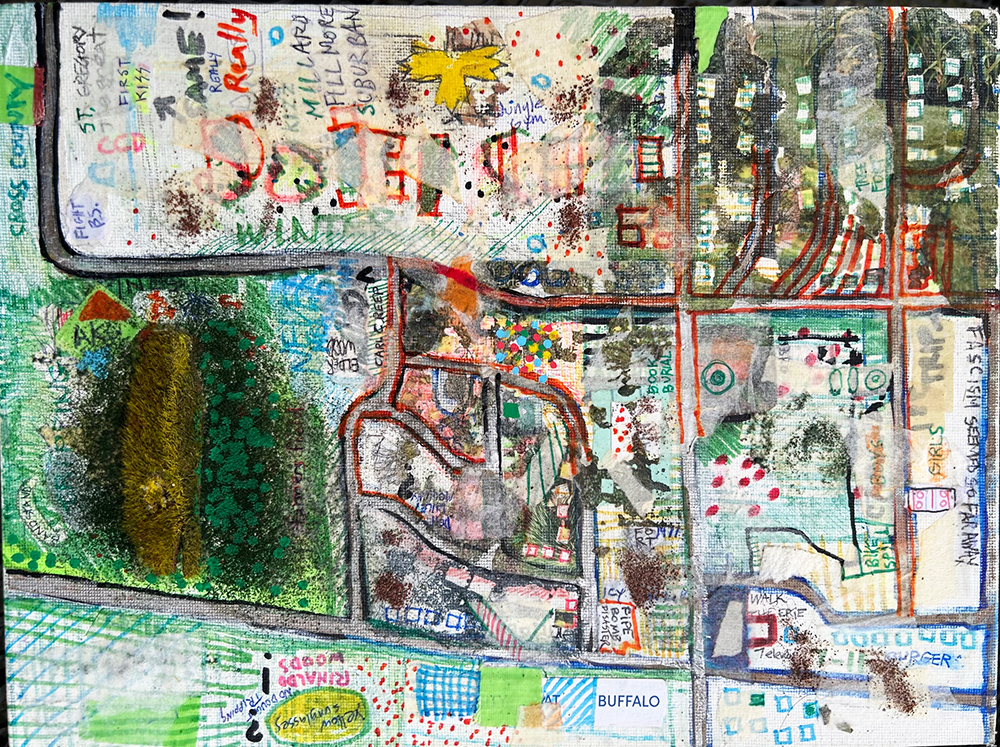
Dec 30: Rachel Abrams
Legend:
perpetual expected misdirection,
2025, pencil on vellum, 5.8125 x 7.4375″
My proclivity to go the opposite direction I intend, whether it’s moving through space or in the studio, is something I have come to expect and appreciate.
I acknowledge this pattern and embrace that I will arrive at my destination, eventually, learning and adapting as I go—the experience creating new pathways that have the potential to branch out to parts unknown.
About:
Rachel B. Abrams
https://www.instagram.com/rachel_b_abrams
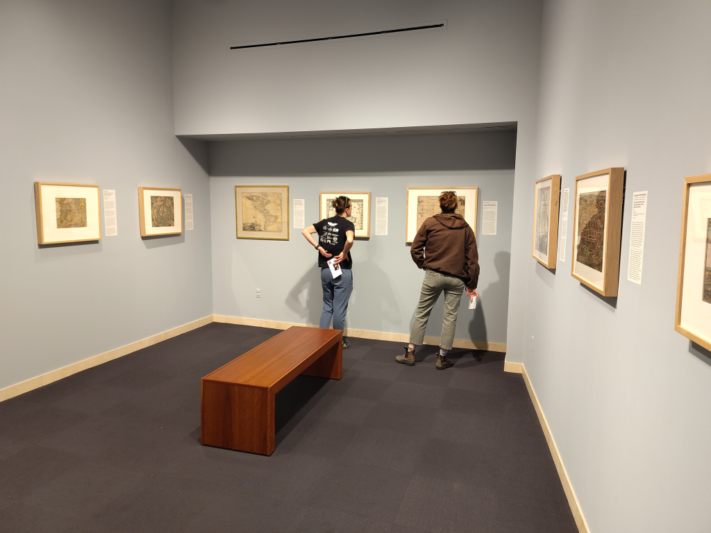
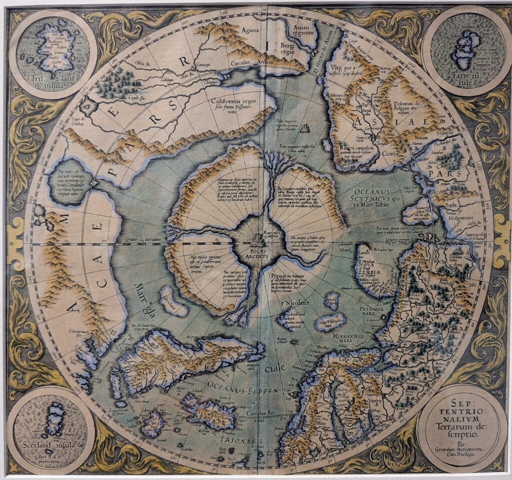
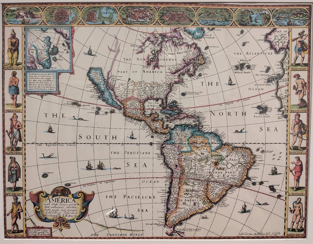
Dec 31: Maps and Marginalia: Marking the Unknown
On View @ the ABQ Museum thru Apr 5, 2026Maps and Marginalia: Marking the Unknown
Legend:
Legend:
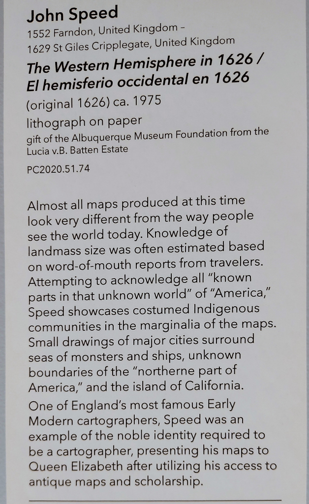
About:
The exhibit, Maps & Marginalia: Mapping the Unknown, features about a dozen maps from the Albuquerque Museum’s collection, dating from ca. 1500-1700.
As evidenced in the two-fer of maps today, these are detailed and wondrous works. These two maps by Mercator and Speed are among my favorites in the show.
In conceiving the Xmaps project, I was first focused on the notion of maps being the essential narrative visual(but not ALWAYS visual) form: a crafted piece that exists to communicate a very specific set of data to a specific audience. In visiting this exhibit, I am further struck by how these maps were very much, quite early exercises in abstraction. Likely based on multiple data sets; measurements, observations, and conjecture, the resulting depictions of either unknown lands or “kind-of known lands” are far from truly representational, and very much closer to editorial/sensorial distortions – an inadvertent artifact that was to be an intentional methodology for modernist artists of the 20th Century. To me, these maps have a bit of the energy of a Surrealist exquisite corpse in which best guesses and/or whimsical flights linked to form their own native logic.
Spotlighted in this exhibit is not only the terrain depicted in the maps, but the marginalia – the additional editorial elements that give context and framing to the territories depicted in the map. In the case of the map of The Western Hemisphere in 1626 by John Speed, the maker has described the cast of players invested in the territorial scene depicted, as if in a board game. But really, this marginalia is an extension of the Legend of the map, priming the viewer to see as the maker wishes them to see, and read the contents of his map.
The exhibit remains on view through April 5 of 2026.